

As Texas Republicans try to muscle a rare mid-decade redistricting bill through the Legislature to help Republicans gain seats in Congress – at President Donald Trump’s request – residents in Austin, the state capital, could find themselves sharing a district with rural Texans more than 300 miles away.
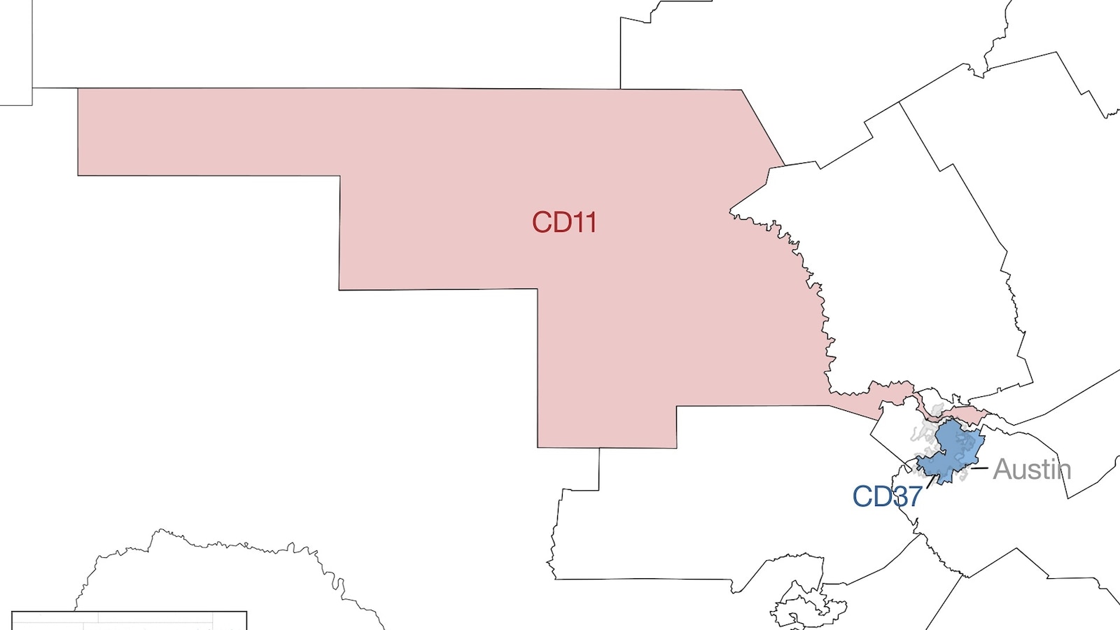
The proposed map chops up Central Texas’ 37th Congressional District, which is currently represented by Democrat Rep. Lloyd Doggett, will be consumed by four neighboring districts, three of which Republicans now hold.
One of those portions of the Austin-area district was drawn to be part of the 11th District that Republican Rep. August Pfluger represents, which stretches into rural Ector County, about 20 miles away from the New Mexico border.
what fucking idiotic ideas. why, I am curious, are districts not drawn by immutable things like latitude and longitude?
Because you have to take into account population numbers. The same number of people represented per representative(in the house) in a given state is one of the points of census.
that’s just a ratio - population / max ppl in cohort.
On a basic level the stuff rural populations need/care about is different than urban populations and suburban is again different. Whether thats farming subsidies, car pollution/traffic, etc.
Dividing simply by lat x long gives all the power to the urban areas. Like a 3rd of NY lives in NYC. However you slice rural areas on the west or north of the state hundreds of miles away with very different concerns would end up getting represented by people from the city while people on the outskirts of the city get represented by rural area interests again hundreds of miles away. And you’d still have arguments about whether to slice longitude or latitude for whatever possible advantage that could give one side or another.
Then you say OK we’ll just sorta cube the city and make a big rural area and thats basically how things started in the first place. Then you have people argue they are better fit for the district next to them try and squiggly the lines et viola you’re just back to where we are now.
Really what is needed is an open-source algorithm that we agree is fair and apolitical. But fat chance of that right now.
i agree re an open source algo! but also - if things are so vastly different then maybe a solution is county based or make new states, etc.
not easy or simple.
but gerrymandering is so freaking evil.
Physical landmarks like rivers and mountains would be best, but even county lines would be good.
why have districts at all?
Assigning a politician who is accountable to a specific group of people is important. The people can petition one person with requests.
In the Netherlands we have proportional representation, everyone’s vote is equal, you can vote for more than two parties, the votes are divvied out to fill an amount of seats in a parliament, that parliament needs to create coalitions that enact laws from 51% of the seats.
Gerrymandering is not normal and is illegal in most more functioning democracies.
Proportional representation would require ranked choice voting, which is another reform the US sorely needs. If the US had ranked choice voting then each state could be its own district and you would find the candidate that most resonates with your values. Then township seats would be used for local representation. State legislature could also be ranked similarly to National elections.
This is the only sensible way to do it. Arbitrarily-drawn districts are silly, proportional representation serves all those needs but far better.
I get that. Makes me think though … that’s what states and counties are for. Then again my state is smaller than some counties in other states!
Ranked choice voting and proportional representation in National and state government, then townships are the local representation. Even then voters could rank councilors and petition as their ideology aligns.
That doesn’t change much, it’s possible to define this district that way.